|
|
|
Suplemen Mingguan
WARTA ALUMNI SMAN 4 Jakarta
Redaksi wasman4@email.com. . . Edisi Minggu, 1 April 2001
dari Redaksi ......
Rekan-rekan Alumni..
Minggu lalu, stasiun angkasa luar terbesar buatan manusia MIR kembali kebumi setelah menghabiskan masa kerjanya selama 15 tahun. Hal ini menarik untuk dicermati. Demikian pula dengan penganugerahan Oscar.
Dalam bilangan hari, Reuni Akbar para Alumni SMAN 4 akan berlangsung. Siapkan kamera Anda untuk mengabadikan momen yang sangat bersejarah ini. Redaksi akan memuat foto-foto yang dikirimkan dalam situs ini. Mudah-mudahan album tersebut akan dapat dipertahankan untuk masa 50 tahun mendatang. Insya Allah...
Arkeologi
Pharos lighthouse, one of the Seven Wonders of the Ancient World
Mapping the Treasures.
By Colin Clement
Klik pada gambar untuk download rekaman video. Playback dengan Vivo.
For many years, tales were told in Alexandria of fabulous statues and engraved blocks that were littered across the seafloor just outside the eastern harbor, but the area was a military zone -- off-limits to scientific investigation. All that changed in the fall of 1994, when a team of archaeologists started to explore the area in earnest. (To learn more about what has been found, watch the NOVA program "Treasures of the Sunken City" or read our interview with archaeologist Jean Yves Empereur.)
As with any archaeological site, the plotting of a detailed and accurate map of the mass of ruins is a necessary first step to figuring out what one has actually found. And in this case, the very nature of the underwater site precluded the possibility of returning day after day in whatever weather to have a look at the site. The map making has been a major undertaking, for two main reasons. First, the field of ruins under examination extends over 5.5 acres, making it one of the largest underwater archaeological sites in the Mediterranean. To further complicate matters, the pieces often lie on top of each other; in some areas there were veritable hillocks of blocks. In order to map the site effectively, the team set about to create a giant and detailed database, the likes of which has never been used in archaeology before.
The team began by establishing a fixed position Electronic Distance Measurement station (EDM) -- effectively, an electronic theodolite -- on the shore. This is used to "spot" the underwater blocks, which are indicated by a reflector mounted upon a floating mast. The mast is connected to a lead line that in turn is placed against the four corners of the submerged block and held in position by a diver. Another diver, on the surface, ensures that the correct tension is maintained and that the floating mast doesn't move too much. This technique was accurate to between 4 and 12 inches, depending on sea conditions, and was the sole option given the need to relate the underwater site to other archaeological sites on land in Alexandria.At the end of each day's dive, the information stored in the memory of the EDM is imported into computers by means of a specialist topography software, called Caltop, which was designed in France. This permits the plotting of the general map of the site, and it also means that partial charts can be given to the divers the following day to help orientate them underwater and to allow the divers to plot and sketch complementary features of the blocks. (The divers are able to draw underwater using synthetic calque paper and plastic lead pencils.)
This rapid, 24-hour turnaround in what began as an experimental method has contributed enormously to the progress of the excavation. It also seems clear that this technique can now be applied to other underwater sites around the world. In theory, it doesn't matter how far underwater the archaeological site is, as long as calm conditions prevail. The only constraint is the distance of the site from the shore, because the EDM has an effective radius of about one and a quarter miles. However, the majority of underwater archaeological sites are usually within this distance.
Two other methods are used to map the site: triangulation, using several permanently fixed underwater reference markers; and the Global Positioning System (GPS). The expedition was fortunate enough to be loaned a state-of-the-art GPS (accurate to within one centimeter, or 0.4 inches) by the Swiss company Leica. When this GPS device is mounted on a rubber dinghy and combined with a sonar device, it gives an exact reading of the contours of the seabed. This information is particularly relevant in analyzing the formation of the site, given the strong possibility that part of what is now the seabed was dry land in antiquity.
The mass of data accumulated over almost ten months of diving has all gone into a giant computerized database. Three types of information on each registered block -- written, drawn, photo and/or film -- has been recorded and can be combined to produce either on-screen or hard copy identification sheets. The addition of extensive photography and video film, which can be paused and rewound, makes the site much easier to study, since the blocks themselves are underwater. Furthermore, a simple click on any individual element on the map can bring up the relevant block identification sheet. The system can also respond to specific demands to plot only those blocks corresponding to certain criteria (form, volume, orientation, material, etc.). For example, at the push of a button, the computer will bring on screen a map of only those blocks identified as columns, or statuary, or those over a certain weight.
The creation of the block identification sheets has made it possible to define the type of blocks discovered and to develop a terminology. In architecture, terminology is linked to the function of a block in the construction -- a lintel is only so-called because it serves as a lintel -- but here we are dealing with an essentially unknown construction or constructions and the majority of elements are lying completely out of context. The new terminology that is being established must ignore the idea of function and look, instead, at four criteria: form, dimension, volume, and decoration. Obviously, this very activity brings blocks together into identifiable groups and is the first step on the road to interpretation.
What the database has already made clear is that the site is made up mostly of materials that have been recycled or pillaged, in the time-honored Egyptian fashion, from pre-existing structures in the Nile Delta and at Heliopolis. There are clear signs of the application of Graeco-Macedonian technological savoir faire to thoroughly Egyptian architectural materials (more than 90 percent of the blocks are of granite), and this juxtaposition, in itself, will throw light upon the style and method of construction of the Pharos lighthouse. In other words, it is likely that the Pharos was not built in purely Greek style, because the Greeks had no experience of building with granite and would have had to use local labor. On the other hand, the Pharos would not have been purely Egyptian, because the Greeks commissioned it. In addition, the significant amount of statuary discovered and the evidence of other complete structures underwater could lead to a new notion of the Pharos as part of a greater complex, and spur interpretations as to its civic and or religious function.
Clearly, the architectural analysis of the Pharos site is still in its infancy and presents a formidable challenge. The only blocks that can be dated even approximately are those bearing decoration -- moldings, inscriptions, statuary, etc. -- and there are relatively few of these. The fact that the majority of the material has been recycled also presents a challenge. Any masons' marks or traces of construction techniques could either be from the original structure or from the building of the Pharos itself. In fact, before any architectural analysis can be definitively broached, the long, painstaking, and at times tedious accumulation of data must be completed. The 2,110 blocks recorded as of the end of June 1997 may comprise the totality of the upper layers, but until access can be gained to what lies beneath, the study of the site will not be complete. (It is anyone's guess how many more artifacts have yet to be uncovered.) At the same time, there is a need to polish and fine-tune the established database.
However, the aim of the game remains to produce hand-drawn and computer-generated reconstitutions of architectural elements that now lie in pieces on the bed of the Mediterranean Sea and to advance a clear hypothesis as to the spatial arrangement of the site. Given enough time and resources, this is indeed possible.
Colin Clement, originally from Edinburgh, Scotland, is a writer and translator who has lived in Alexandria for the past eight years. Since 1994 he has been working closely with the Centre d'Etudes Alexandrines (Center for Alexandrian Studies) researching, compiling and editing reports and closely following the various archaeological excavations of the Centre.
Klik untuk Info lengkap
.
Academy
Awards
ACTOR -- LEADING
Russell Crowe GLADIATOR
ACTRESS -- LEADING
Julia Roberts ERIN BROCKOVICH
BEST PICTURE
GLADIATOR
Douglas Wick, David Franzoni,
Branko Lustig
FOREIGN LANGUAGE FILM
CROUCHING TIGER, HIDDEN DRAGON
Ang Lee
Hobby
KOLEKSI MATA UANG
Salah satu kegemaran para pelancong dunia dalah mengumpulkan mata uang kertas maupun koin dari pelbagai negara yang dikunjunginya. Banyak pula para kolektor serius mengumpulkannya dan diperdagangkan, terutama mata uang yang sudah tidak beredar lagi atau mata uang "kuno"
Melalui kolom ini Anda kami hubungkan dengan situs yang menampilkan koleksi amatir dari pelbagai mata uang kertas di dunia. Sayangnya, para konglomerat kita yang juga punya hobi koleksi uang tidak memiliki situs untuk menampilkan koleksinya ;-)
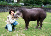
Satwa Langka
What are tapirs and why are they interesting?Well, they're one of the lesser known large animals in the world. They weigh between about 350 and 800 pounds, depending on which species you're talking about. Their closest relatives are horses and rhinos and they inhabit jungle and forest lands in Central and South America as well as in Southeast Asia. (An unusual distribution, which can hardly be overlooked by anyone interested in geomorphology.)
All four species are considered by one list or another to be endangered. They have flexible snouts that are fun to watch, and the young look like striped watermelons on legs. With luck, a tapir will live about 25-30 years. If you've ever stood quietly by a tapir pen at a zoo, you've probably heard curious people who haven't read the sign yet calling them pigs, anteaters, armadillos, aardvarks and even bears. As I mentioned, they're not all that well known.
Not big like an elephant, humanoid like a chimpanzee, strikingly built like a giraffe, ferocious like a lion, neither commonly seen nor beautifully colored, they're often overlooked.
Retaining many prehistoric characteristics, they've been referred to as "living fossils," and "creatures that time forgot." If you saw the movie 2001: A Space Odyssey, these are the critters director Stanley Kubrick chose to inhabit his prehistoric world along with proto humans. It was a tapir bone, hurled into the air, that dissolved so magically into the future.
Water-loving, a tapir not only swims well, but has the ability to walk on the bottom of ponds and rivers. It's often said that tapirs are "docile," but they may also throw tantrums, during which they will sometimes gnash and bite. Strong as an ox and nearly indestructible (I knew one tapir that liked to toss a cast-iron bathtub around his yard), tapirs emit chirp-chirping sounds that you could easily mistake for a bird. They'll eat almost anything, but a favorite food is, almost universally, bananas
In the literature, tapirs have been called "stupid," "clumsy" and "awkward," none of which are true. A domesticated tapir may not come when you call its name and it won't walk on a leash, but it's far from being stupid. It may appear to be ungainly, yet it can turn on a dime, out-maneuver a Weimaraner while playing "tag," can figure out how to open a standard round doorknob, drink water from a Coke bottle, nibble carefully from a fork, and learn to recognize the sound of one car engine over another. With its keen sense of smell, a tapir can pick up the scent of a lettuce leaf yards away. And speaking of lettuce, the closest I can come to describing the smell of a tapir is to say it smells like a crate of lettuce!
Lastly, there's a story I found amusing, and I hope someday I can again locate the source. Apparently the great French zoologist, Cuvier (I think it was Cuvier), announced to the world one year that all the large land mammals had been discovered - there would be no more found. The very next year, the Malayan tapir became known to Western science. I hope I have this information right, and I don't offhand know the year, but it's such a good story I had to tell it. Thank you for visiting the Tapir Gallery. I hope you'll stay and spend a little time with these anomalous, unique and under-appreciated animals. Welcome to the fascinating world of tapirs!
Musik & DVD
Color, Surround Sound, Digital Sound
Music videos
"Lucky," "Oops!... I Did It Again," "Stronger"
Britney on Saturday Night Live
"Woodrow the Homeless Man," "Britney Judges Dance Tryouts," "Morning Latte," "Oops!... I Did It Again," "Don't Let Me Be the Last to Know"
Britney in Hawaii, including eight songs performed live. Video jukebox. Photo gallery. Full-screen formatDirgantara
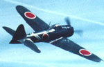
ZERO FIGHTER
The A6M came as a shock to the allied in 1941 -- this despite earlier reports of its appearance in China. For the first time, a carrier fighter had been built that outperformed landplanes. The A6M was fast, extremely maneuvrable, and had an impressive endurance. But this performance had been achieved by the light construction of the aircraft, and this was the undoing of the type when more powerful allied fighters appeared. Development was unable to keep up with the exigencies of the time, and most of the 10964 built had to fight an increasingly superior opposition
A6M1
The Mitsubishi A6M Zero Fighter was the finest shipboard fighter in the world during the first year of the Pacific War. It was the first shipboard fighter capable of defeating its land-based opponents. Its world-wide fame was won in a series of astounding victories against all types of land-based and carrier-based Allied aircraft during the first six months after Pearl Harbor. It took part in every major action in which the Japanese Navy was involved, from Pearl Harbor all the way to the final B-29 assault on Japan. It became a legend in its own time for its extremely good maneuverability and its exceptionally long range. Even today, the Zero remains for the Japanese and their erstwhile enemies alike the symbol of Japanese air power during the Pacific War. Despite the fact that it was largely obsolescent by mid-1943, it remained in production until the end of the war. More Zeros were built than any other type of Japanese aircraft, a total of 10,449 being built at Mitsubishi and Nakajima factories.
Keluarga
Kanal pendidikan keluarga ini diasuh oleh Bapak Soejono yang merupakan pemerhati pendidikan. Para pelajar ataupun orangtua murid bisa melakukan konsultasi secara online mengenai aneka masalah sekolah, penentuan jurusan, dll.
1928 - 1999
BEST PICTURES(1928) WINGS
(1929) THE BROADWAY MELODY
(1930) ALL QUIET ON THE WESTERN FRONT
(1931) CIMARRON
(1932) GRAND HOTEL
(1933) CAVALCADE
(1934) IT HAPPENED ONE NIGHT
(1935) MUTINY ON THE BOUNTY
(1936) THE GREAT ZIEGFELD
(1937) THE LIFE OF EMILE ZOLA
(1938) YOU CAN'T TAKE IT WITH YOU
(1939) GONE WITH THE WIND
(1940) REBECCA
(1941) HOW GREEN WAS MY VALLEY
(1942) MRS. MINIVER
(1943) CASABLANCA
(1944) GOING MY WAY
(1945) THE LOST WEEKEND
(1946) BEST YEARS OF OUR LIVES
(1947) GENTLEMAN'S AGREEMENT
(1948) HAMLET
(1949) ALL THE KING'S MEN
(1950) ALL ABOUT EVE
(1951) AN AMERICAN IN PARIS
(1952) THE GREATEST SHOW ON EARTH
(1953) FROM HERE TO ETERNITY
(1954) ON THE WATERFRONT
(1955) MARTY
(1956) AROUND THE WORLD IN 80 DAYS
(1957) THE BRIDGE OVER THE RIVER KWAI
(1958) GIGI
(1959) BEN-HUR
(1960) THE APARTMENT
(1961) WEST SIDE STORY
(1962) LAWRENCE OF ARABIA
(1963) TOM JONES
(1964) MY FAIR LADY
(1965) THE SOUND OF MUSIC
(1966) A MAN FOR ALL SEASONS
(1967) IN THE HEAT OF THE NIGHT
(1968) OLIVER!
(1969) MIDNIGHT COWBOY
(1970) PATTON
(1971) THE FRENCH CONNECTION
(1972) THE GODFATHER
(1973) THE STING
(1974) THE GODFATHER PART II
(1975) ONE FLEW OVER THE CUCKOO'S NEST
(1976) ROCKY
(1977) ANNIE HALL
(1978) THE DEER HUNTER
(1979) KRAMER VS. KRAMER
(1980) ORDINARY PEOPLE
(1981) CHARIOTS OF FIRE
(1982) GANDHI
(1983) TERMS OF ENDEARMENT
(1984) AMADEUS
(1985) OUT OF AFRICA
(1986) PLATOON
(1987) THE LAST EMPEROR
(1988) RAIN MAN
(1989) DRIVING MISS DAISY
(1990) DANCES WITH WOLVES
(1991) THE SILENCE OF THE LAMBS
(1992) UNFORGIVEN
(1993) SCHINDLER'S LIST
(1994) FORREST GUMP
(1995) BRAVEHEART
(1996) THE ENGLISH PATIENT
(1997) TITANIC
(1998) SHAKESPEARE IN LOVE
(1999) AMERICAN BEAUTY
Top Model
Kristina Semenovskaia
Fabiane Nunez
Wanita Bugar
Foods you can use as Medicine
I’m sure you have head the phrase "You are what you eat". Well did you know that certain foods can also be used as remedies.
Honey: has antibacterial properties that can help heal cuts and open sores. Place a sterile gauze pad saturated
with honey over the wound, and put a dry gauze pad on top of the first one.
Chicken Soup: combats the common cold. The broth has mild antibiotic effect because it contains an amino acid chemically similar to a drug used to treat respiratory infections.
Yogurt: Keeps yeast infections away.
Blueberries: contain a compound that has antibacterial properties effective against the bacteria that’s the chief villain in most cases of diarrhea.
Gingerroot: works wonders against nausea caused by motion sickness and migraines. So when you study a lot and feel a migraine coming on place several slices of fresh gingerroot into a cup of water simmer for ten minutes and enjoy.
Bananas: are great for people with a sensitive stomach. The fruit acts as an antacid.
Danger in the Diet PillsA drug called fen/phen has been enthusiastically promoted to help obese patients lose weight, but it may also lead to serious heart problems. Some fen/phen uses developed a heart condition in which waxy tissue coats the valves preventing them from closing completely. The best advice is less food and more exercise.
Fatness is a Vicious Cycle
The more fat you have, the more your metabolism changes to favor the build up of even more fat. Weight gain only happen when we have so excessively overeaten and under exercised that we exceed the capacity of the muscles to hold internal fat. Exercise increases the metabolic rate, increases the amount of muscle, raises the caloric consuming enzymes inside the muscle, and
increases the burning fat
Parfum
TOP SELLER

COOL WATER FOR MEN
Created by the design house of Davidoff in 1988, Cool Water is classified as a refreshing, spicy, lavender, ambery
fragrance.

GUCCI RUSH
The newest fragrance from Gucci comes in scents for both men and women

FRAGRANCE FOR HER
From the floral scent of Romance to the sporty fragrance of Polo Sport, Ralph Lauren has created a fragrance perfect for every woman

ARMANI FRAGRANCE
Famous for his classic and tailored clothing lines, Giorgio Armani also creates classic fragrances for men and women
Angkasa Luar
MIR SPACE STATION
RE-ENTRY TO EARTH
As planned, Mir's re-entry was sucessfully acomplished on March 23, 2001 at around 05:43 UTC 80 km above the local day-night (dusk) terminator line in the South Pacific at 175 West longitude and 25 South latitude. A graphic of Mir's approximate reentry location is provided by SatSpy 4.01 Mir's orientation was stablized around 02:00 UTC on March 22.
The first burn (duration 21 minutes) at apogee set for 00:33 UTC on March 23 to lower the perigee to 190 km over the planned reentry area using the Progress main engines was reported sucessful.
The second apogee burn (duration 23 minutes) planned for 02:02 UTC to change the orbit to 190 x 160 km was reported sucessful.
The final braking maneuver took place at 05:07 UTC over northern Africa (Libya). The burn ended over Mongolia 22 minutes later. It was planned to have an orbital parameter of 190 x 79 km causing reentry about 34 minutes later with impact at 06:00 UTC.
Klik disini untuk kembali ke WARTA ALUMNI SMAN 4 Jakarta